
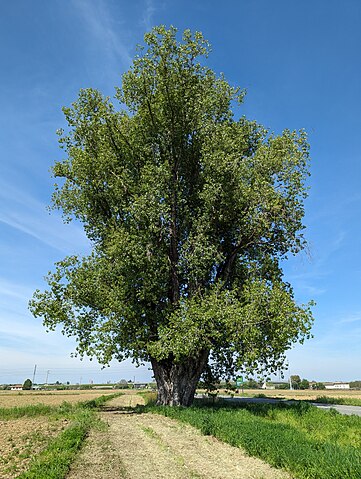
[Semi-automated translation of the Italian diary entry]
On OpenStreetMap, a tree can be represented as a natural=tree node.
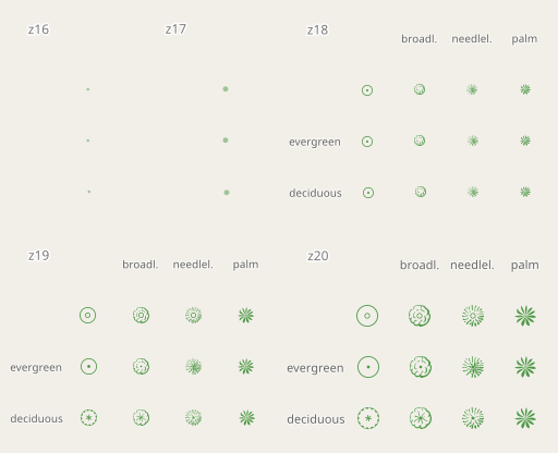
Leaf type 🌿
leaf_type is the most common tree-related tag in the database, this is because it is easily verifiable and is supported with a quest by StreetComplete. The values are broadleaved and needleleaved. Some argue that palms should not be tagged as broadleaved but with a value of their own, =palm.
Leaf cycle 🍂
This tag describes whether a tree is deciduous or evergreen. Most needleleaved tree species are evergreen, but this is not always the case, so do not infer this value automatically. You can add this value easily if you know the species, or more simply if it is autumn/winter. If not, you can try to see if satellite or street-level imagery taken at those times are available.
Genus and species 🌳
If you are not an expert, there are tools that can help you recognise the genus/species of a plant, such as Pl@ntNet and iNaturalist, both of which also exist as mobile apps. On OpenStreetMap there are many trees with species (or species:wikidata or species:xx) that do not have leaf_type or leaf_cycle. These values are of course identical for each species (and also for many genus) and can therefore be easily deduced. There are two lists on the OSM wiki that contain these values for genus and species.
MapComplete has a dedicated tree theme that can be used to enter the species while SCEE has a dedicated quest (“What is the genus or species of this tree?”).
Monumental trees 🏛️
Monumental trees can be mapped adding denotation=natural_monument. In Italy they are recorded by the Ministry of Agriculture, Food Sovereignty and Forests (Masaf) with annual updates. You can map them by adding ref:masaf, which is a unique code assigned by the ministry.
In Poland they are recorded by the ‘Generalna Dyrekcja Ochrony Środowiska’ (GDOŚ) (you can find many of them with a query natural=tree+ref:inspire=*), in Serbia many zapis (sacred trees) are mapped with ref:zapis while b-unicycling has recently documented the place_of_worship=sacred_tree tag to map rag trees in Ireland and Scotland.
Rendering 🎨
Trees are rendered on Carto as green circles with a brown dot in their centre, regardless of their attributes. 
The Straßenraumkarte Neukölln renderer shows the trees differently according to leaf_type, circumference and diameter_crown. However, the web map only works for the Berlin district of the same name.
F4 Map and Streets GL (no longer updated) are 3D renderers that use the height tag. F4 Map distinguishes trees by foliage type and also supports some values to differentiate palm trees. Esri also has a 3D map that uses OSM data, and which should support height and also some genus values.
On the IMAGICO.De blog, there is an interesting article that goes into detail on possible renderings to highlight the various attributes.
QA 🛠️
There are more than 20,000 mapped trees, but QA tools are still few. That is why I created this MapRoulette project: Tree Validation.
There are challenges that compare values in the database with the largest values ever recorded in nature, for example trees taller than Hyperion. Other challenges concern uncommon or incorrect values of denotation, species, genus, leaf_cycle or leaf_type.
The hope is that in the future more and more tools will check on tree tagging. For now there is at least one open issue for Name Suggestion Index and one for Osmose/JOSM.
If you want to discuss trees on OSM, you can use the “tree” tag on the OpenStreetMap Community Forum.
Have fun mapping!
Discussion
Comment from Colbertson on 29 April 2024 at 07:08
One useful QA tool for genus and species is http://taginfo.geofabrik.de/ and sorting alphabetically, lots of capitalisation or typo issues.
Comment from mycota on 1 May 2024 at 00:23
One of the issues with tagging plant names is that the names change over time. For example, Prosopis velutina is a very common tree in my area (velvet mesquite). But the name was recently changed to Neltuma velutina. Most people still call it Prosopis, and will likely do so for years, as it takes time for the public to adapt to name changes. So it would be confusing to change every instance of the old name to the new name. There doesn’t seem to be a method for tagging taxonomic synonyms in OSM. It seems the best option is to use the wikidata tag and make sure wikidata is updated with the current name and synonyms.
Comment from Awo on 12 May 2024 at 07:12
Thanks for the MapRoulette project: Tree Validation. I have been using it to correct the Chile data, and it has been a great help. Regarding monumental or singular trees, in Chile we prefer the label monument=tree for this type of trees, at the national level there is not yet a legal body for their protection. On the other hand, there are 07 species of trees that are legally declared as natural monuments, which coincides with the label denotation=natural_monument, this can lead to confusion. A monumental or singular tree is not necessarily a “natural monument”. The preservation approach should be expanded by adding the concept of priority tree individuals (or genes). On another topic, we are mapping all Chilean palms to date, about 2750, and we consider that the label leaf_type=palm.