StephaneP's Diary Comments
Diary Comments added by StephaneP
| Post | When | Comment |
|---|---|---|
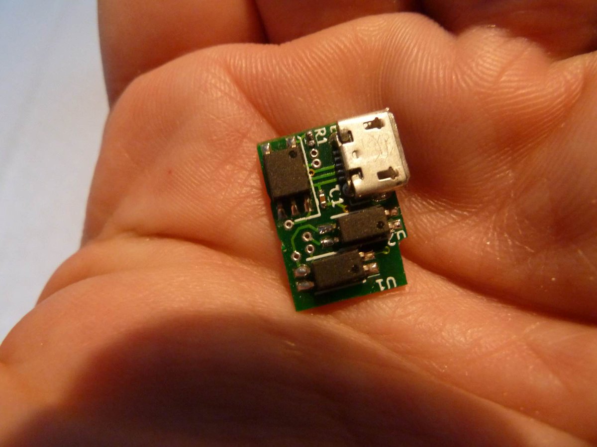
| Shall you buy an Insta360 X3 camera for street-level imagery? | @matheusgomesms Did you compare side by side the Gopro Max and the X3 ? The last time I did it, the quality wasn’t really better for the X3. That was … different. Wow, that’s an old post :-) It was working only for static capture. Since then, I’ve added some Pcb to control the camera and get a good sync to be able to capture 360 images when I walk, a good Gnss receiver (RTK), and many other things. Here is a recent sequence currently in blurring process : https://panoramax.openstreetmap.fr/#focus=pic&map=20/48.8787651/2.3585719&pic=9915ecc4-0c8b-47df-860c-3b3eed2f1997&speed=250&xyz=188.41/-5.88/30 @jakecopp Your post inspired me a lot when I read it last year! I was trying the same thing, but I didn’t success with large areas. |
|
| Regarding OSM GPS Traces | Osm should add a “geofence” feature. That way, gpx file would be cut near where we live/work/other area we want to hide…. |
|
| Shall you buy an Insta360 X3 camera for street-level imagery? | I’ve used Insta 360 X3, Pro, and Titan. I don’t understand people who say that Insta software is way better than Gopro, IMHO Insta360 is not good at all. Maybe it’s ok for video capture, but not for our goal : StreetView images. Yes, you can use multiple camera to get a better resolution, and it’s exactly what I do, with 6 cameras. But trust me, it’s not easy. |
|
| Direction-Tag subtiler Bedeutungsunterschied Geltungsrichtung vs. Blickrichtung, z.B. bei bei z.B. highway=give_way und highway=stop | Hello ! Just to let you know that i’ve just release a style for Josm which displays the traffic sign direction. I hope it will help the contributors to add the direction tags. https://framapiaf.org/@Stfmani/111189046166414211
|
|
| Cartographie de fauteuil des Côtes d'Armor: première étape terminée ! | Bravo ! J’ai dégommé le rose pour le sud de la Loire-Atlantique, et maintenant j’attaque le nord. Je sais à quel point c’est long, alors que je ne vais pas autant dans les détails que toi. Alors encore bravo !! Et mille merci pour ne pas avoir collé les landuse sur les routes ;-) |
|
| Affordable, High Quality 360 Street Level Imagery using GoPro Fusion and Ardusimple | Thanks, For the stitching process, I use Hugin and some scripts to automate the process : https://github.com/Stefal/Stitching_scripts I made some custom PCB to control the cameras, and include them inside it. A raspberry and an arduino send commands to the 6 cams. There are some pictures here: https://twitter.com/i/events/786551055387467778
|
|
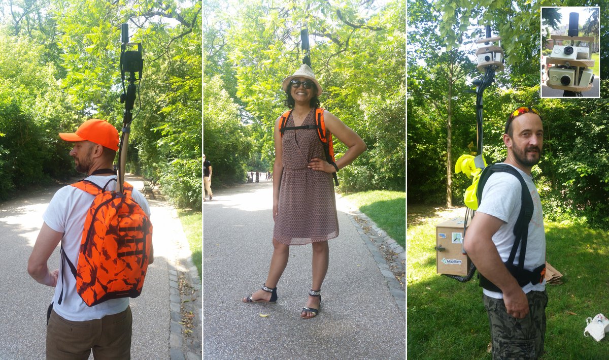
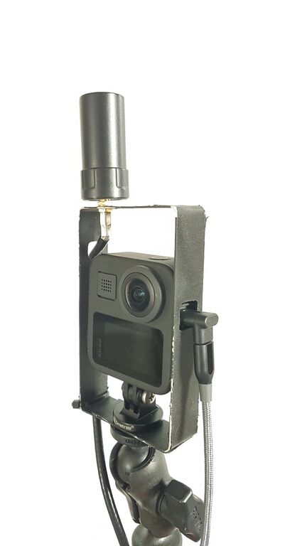
| Affordable, High Quality 360 Street Level Imagery using GoPro Fusion and Ardusimple | Yes, the helical antenna isn’t visible on the jpeg, and don’t need a ground plane like the ann-mb. It’s not the perfect setup because as you noticed we have to turn the Max to open the SD slot, but it’s a good solution for pedestrian capture. Maybe we should use some more rigid metal to create an enclosure more open near the SD slot. left to right: GoPro Max, Theta Z1, my own custom V6Mpack
BTW: We usually use Lefebure Ntrip Client. I love the always visible Gps/Float/Rtk icon on the android notification bar. When I don’t need this icon, I use this FOSS android client https://github.com/ykasidit/bluetooth_gnss |
|
| Affordable, High Quality 360 Street Level Imagery using GoPro Fusion and Ardusimple | For the antenna, we choose a different setup, with an helicoidal antenna on top of the cam :
|
|
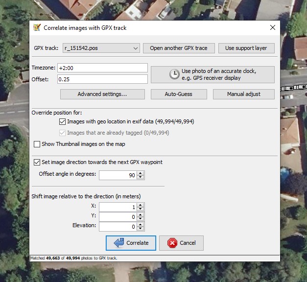
| Affordable, High Quality 360 Street Level Imagery using GoPro Fusion and Ardusimple | Hi! Nice setup! For the gpx/jpeg correlation, you shoud try Josm, it’s the best solution I know, with all the available aerial imageries, subsecond time, offset, direction and position offset.
|
|
| Simple F9P (rtk) howto | @Marcos Dione I don’t know any phone with a connector for an external antenna. The only solution I know is using an external bluetooth receiver. |
|
| Simple F9P (rtk) howto | @kucai
smartphones usually have a bad gnss antenna. You can look at this articles: |
|
| Simple F9P (rtk) howto | Hi, If you want to build your own Rover, there is some documentation (in french) here : https://docs.centipede.fr/docs/make_rover/materiel.html Or you can buy some ready to use rovers from company like Sparkfun (RTK Surveyor, RTK Express). I have build my own “dirty” logger, based on this work : https://github.com/PaulZC/F9P_RAWX_Logger |
|
| Real Time Kinetics | @grin Sure, http://centipede.fr and the caster is caster.centipede.fr, port number : 2101 |
|
| Real Time Kinetics | Hi! If you want to build your own base station, I wrote some code that could help you : https://github.com/Stefal/rtkbase In France we now have an open gnss network with about 200 base stations. |
|
| External Bluetooth GPS receiver unit, Android 11 and Custom ROMs | @AkuAnakTimur, could you test it ? |
|
| Capturing imagery using an off-the-shelf dashcam (Viofo A129 Duo) | Hi!
For the rear camera, you will have to add these parameters: I’ve uploaded some WildAtlanticWay images a long time ago, 2015 I think. :-) |
|
| External Bluetooth GPS receiver unit, Android 11 and Custom ROMs | Hi! There are some BlueGps forks. I have one which works: https://github.com/Stefal/bluegnss4droid (beta apk available) It’s not perfect, and I had some crashes with it, but it’s open source, so anybody could fix the remaining bugs and publish it on F-droid. |
|
| You thought OpenStreetMap data uses the WGS84 datum? No it doesn't! | @kgjenkins that makes sense. I’d like we can embed images directly on the osm.org servers. After a few years a big part of diary images are not correctly linked anymore. |
|
| You thought OpenStreetMap data uses the WGS84 datum? No it doesn't! | @kgjenkins It works here. If you use some ads blocker or privacy addon inside your browser, check them. |
|
| How to highlight high-precision GPX traces? | I forgot to say that now, you can open RTKLib .pos files inside Josm. It helps me a lot : https://josm.openstreetmap.de/ticket/17829 |