OpenStreetMap logo OpenStreetMap

Reinhart Previano's Diary

Recent diary entries

Pertama-tama, saya mengucapkan Selamat Tahun Baru yang ke 2020!!!

Screenshot Description

Dengan maraknya program Gerakan Nasional Non Tunai (GNNT) yang diselenggarakan pemerintah sejak 2014, saya mengajak para penyunting peta (editor/mapper) untuk bersama-sama memetakan metode pembayaran yang diterima di Indonesia, misalnya dalam restoran, kafe, tempat parkir, halte, jalan tol, tetokoan, dan lain-lain.

Untuk Apa Dipetakan?

Dengan memetakan pembayaran nontunai di OpenStreetMap, para pengguna dapat langsung mengetahui pembayaran yang diterima dalam tempat tersebut (setidaknya di dalam situs www.openstreetmap.org). Hal ini akan memudahkan mereka untuk mencari tempat-tempat yang menawarkan penawaran diskon/cashback dengan lebih cepat dibandingkan dengan peta daring (online) lainnya.

Screenshot Description 
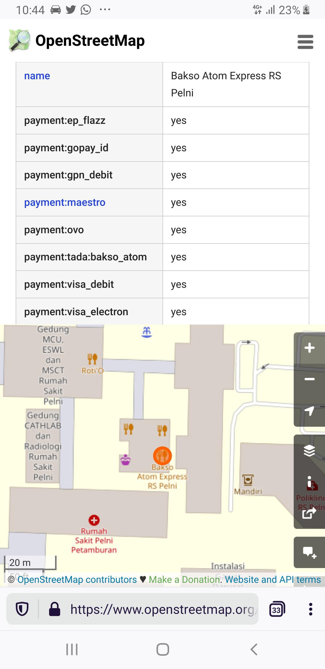
Nah, kalau gini kan saya sudah tahu restoran ini bisa bayar pakai apa…

Screenshot Description 
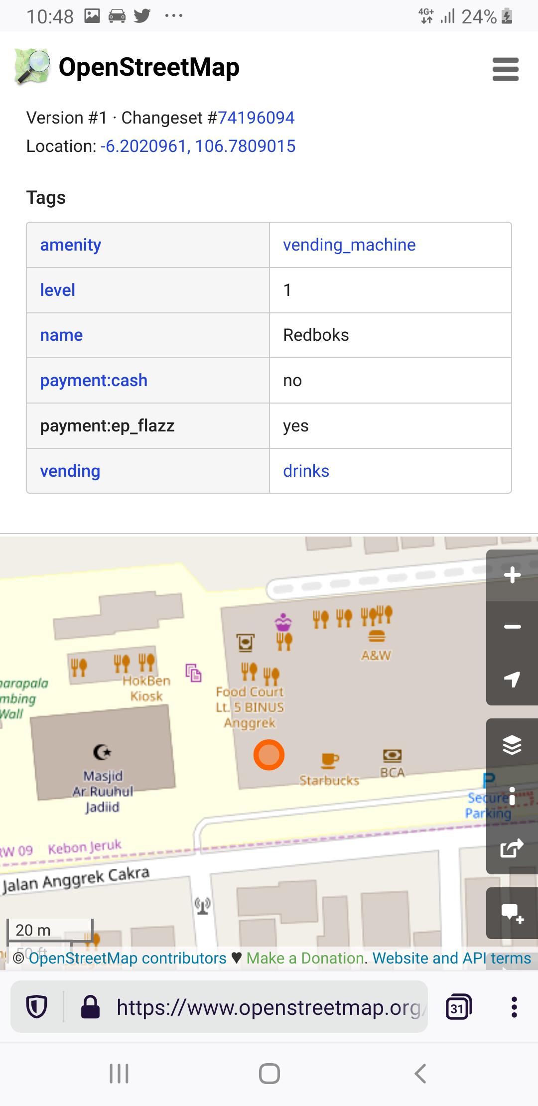
Oh, ternyata mesin vending minuman ini cuman bisa bayar pakai Flazz…

Screenshot Description 
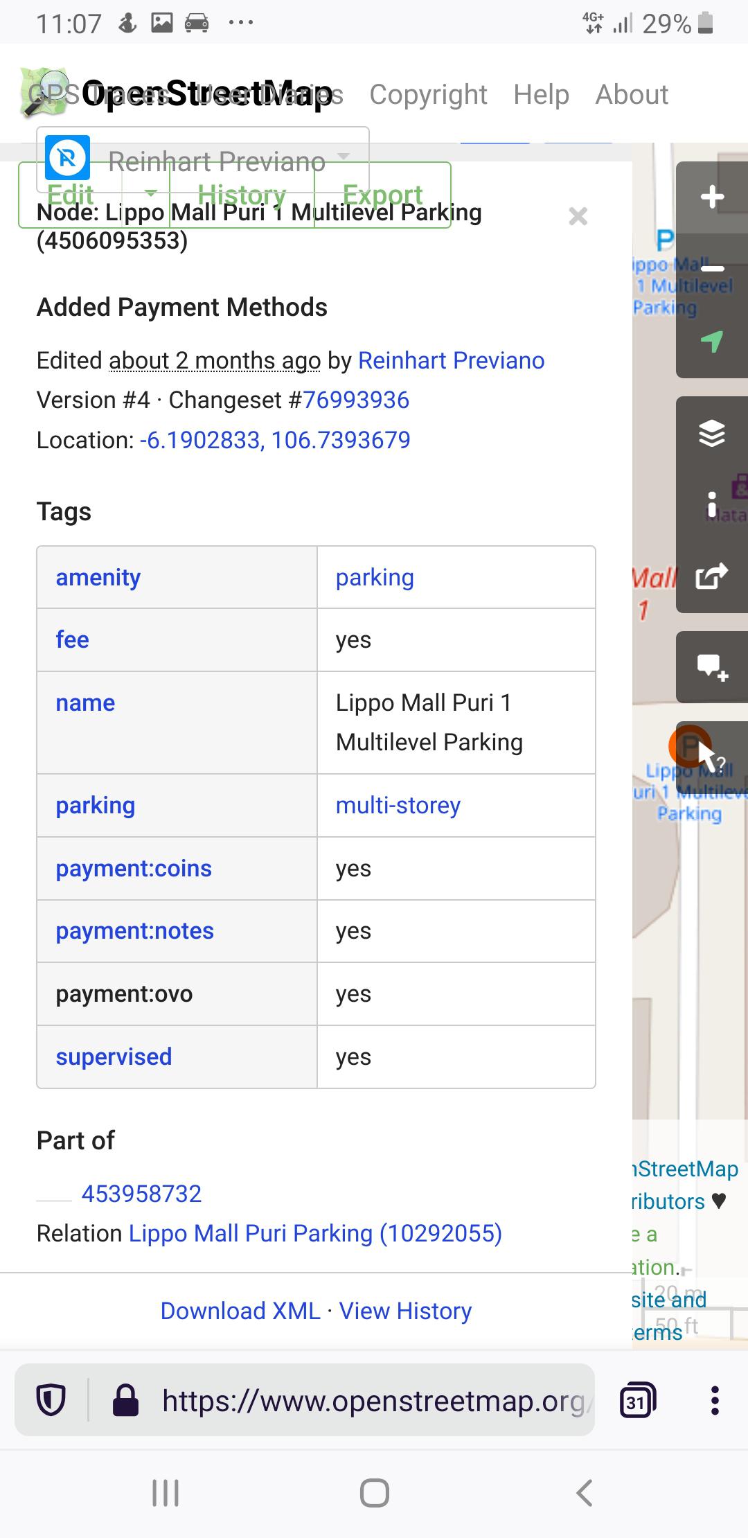
Bayar parkir lewat aplikasi bisa dapat cashback? Di sini ya?

Secara tidak langsung kita juga dapat melihat pergerakan pembayaran digital di Indonesia (misal. dengan melihat frekuensi jumlah merchant pembayaran digital yang ada dalam perkotaan hingga pedesaan), serta memperbaiki kualitas data peta Indonesia dalam OpenStreetMap. Ini semua karena database OpenStreetMap sangat terbuka bagi siapa saja untuk mengunduh dan mengolahnya.

image 
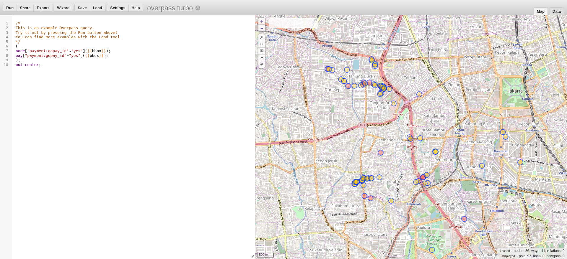
Contoh hasil pencarian Overpass Turbo terhadap tetokoan yang menerima pembayaran menggunakan GoPay

Panduan Tagging (Penandaan)

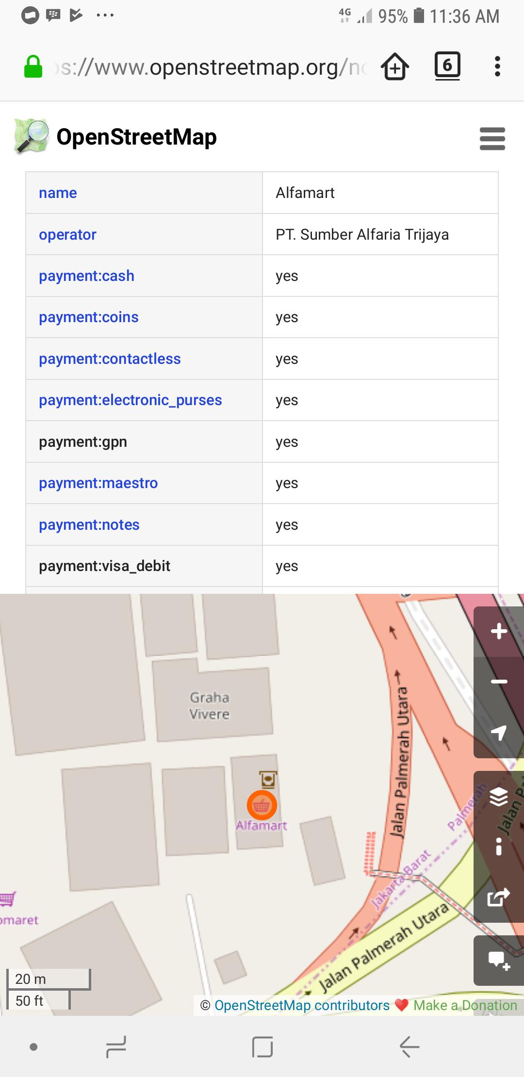
Kalau bisa bayar pakai uang tunai, tandai dengan payment:cash=yes. Kalau tidak bisa, tandai dengan payment:cash=no.

Kalau bisa bayar pakai kartu uang elektronik, tandai dengan:

  • payment:ep_flazz=yes untuk Flazz (BCA, Danamon, dll.)
  • payment:ep_mandiri_emoney=yes untuk Mandiri e-money (Bank Mandiri)
  • payment:ep_brizzi=yes untuk BRIZZI (BRI)
  • payment:ep_tapcash=yes untuk TapCash (BNI)
  • payment:ep_bsbcash=yes untuk BSB Cash (Bank Sumsel Babel)
  • payment:ep_jak_lingko=yes untuk kartu Jak Lingko (Transjakarta/MRT Jakarta/Pemprov DKI Jakarta)
  • payment:ep_jakcard=yes untuk kartu JakCard (Bank DKI)
  • payment:ep_megacash=yes untuk kartu MEGACASH (Bank MEGA)
  • payment:ep_nobu_emoney=yes untuk kartu NOBU E-Money (Bank NOBU)

Kalau bisa bayar pakai aplikasi dompet digital (ya, yang ada banyak promo cashback-nya), tandai dengan:

  • payment:gopay_id=yes untuk GoPay (untuk membedakan dari [GOPAY (Malaysia)])(https://gopay.com.my)
  • payment:ovo=yes untuk OVO, dan juga payment:grabpay=yes untuk stiker QR Code milik OVO (karena bisa bayar lewat aplikasi Grab)
  • payment:linkaja=yes untuk LinkAja
  • payment:dana=yes dan payment:samsung_pay=yes untuk DANA
  • payment:yukk=yes untuk YUKK
  • payment:shopeepay=yes untuk ShopeePay
  • payment:isaku=yes untuk i.saku
  • payment:cashbac=yes untuk Cashbac
  • payment:bluepay=yes untuk BLUEPay (diterima di semua vending machine BlueMart)
  • payment:akulaku=yes untuk Akulaku Pay
  • payment:dimo_pay=yes untuk Dimo Pay by QR (Untuk aplikasi seperti PayTren)
  • payment:otto_pay=yes untuk stiker QR Code OttoPay (misal. di Indomaret dan KFC; untuk aplikasi seperti OttoCash dan Bank DKI JakMobile)

Kalau tempat tersebut dapat menerima pembayaran melalui QRIS (QR Code Indonesian Standard) tandai dengan payment:gpn_qris=yes dan payment:<nama bank atau dompet digital yang mengeluarkan kode QRIS>:gpn_qris=yes, misalnya:

image

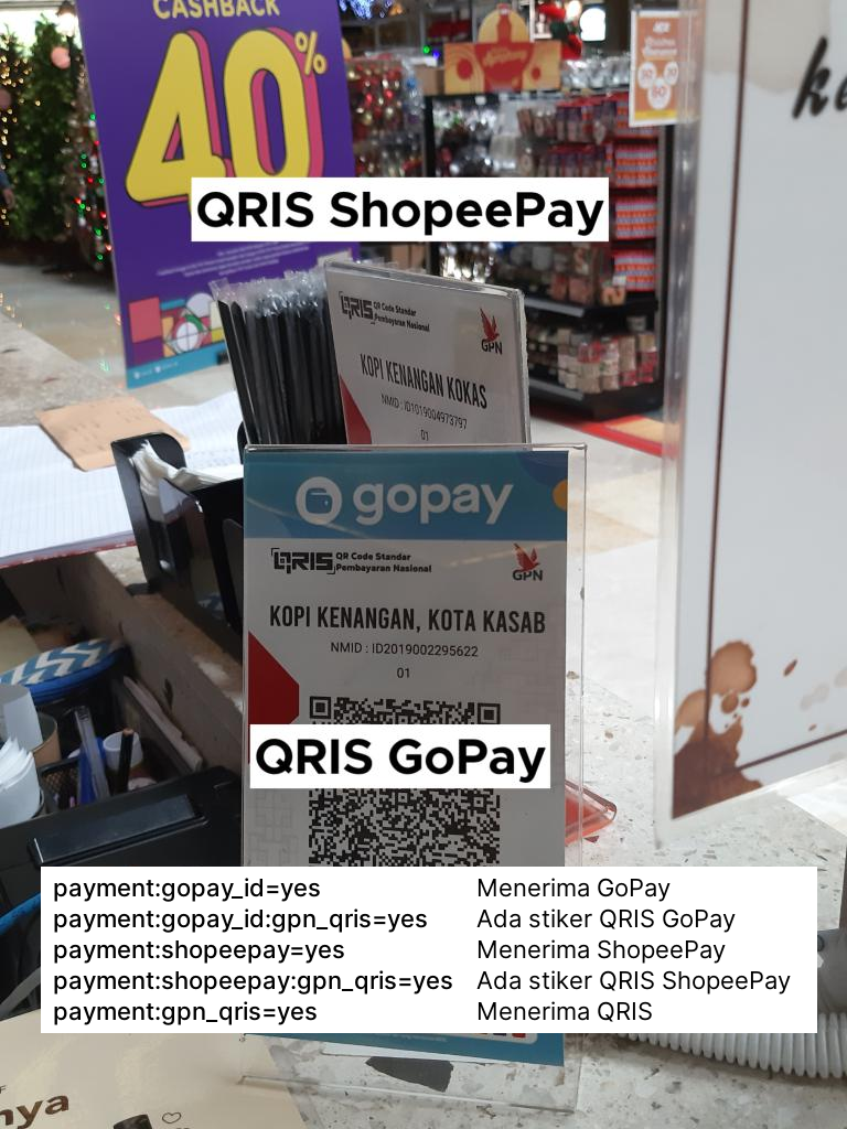
Untuk QR Code GoPay, hanya tandai payment:gpn_qris=yes dan payment:gopay_id:gpn_qris=yes jika mempunyai QR Code yang berlogo QRIS.

Khusus untuk kartu debit dan kartu kredit, Anda harus menandai masing-masing tag berikut:

  • payment:gpn_debit=yes untuk GPN
  • payment:bca_card=yes untuk BCA Card (biasanya diterima di seluruh EDC BCA)
  • payment:mastercard=yes dan payment:visa=yes untuk kartu kredit Mastercard dan Visa (umumnya diterima dalam semua EDC bank di Indonesia)
  • payment:maestro=yes, payment:mastercard_debit=yes, payment:visa_debit=yes, dan payment:visa_electron=yes untuk kartu debit Mastercard dan Visa (umumnya diterima di semua EDC bank di Indonesia)
  • payment:american_express=yes untuk kartu debit American Express (AMEX)
  • payment:jcb=yes untuk kartu kredit JCB
  • payment:unionpay untuk kartu kredit UnionPay

Ada Pertanyaan?

Jika ada berbagai pertanyaan, silakan bertanya di kolom komentar bawah ini. Saat ini saya juga aktif dalam memetakan restoran di sekitar Slipi, Tanjung Duren, dan Kemanggisan (bisa dibuktikan di situs HDYC). Terima kasih.

Months after I announced this upgrade project I’d like to announce that Transjakarta Corridor 9 has finally become the second (and currently longest) fully-validated route (next after MRT Jakarta in Jakarta, according to Geofabrik OSM Inspector Tools.

And that also means I’m closing https://gitlab.com/reinhart1010/osm-transjakarta-v2/issues/9 as fixed.

image

Similar to the MRT, Corridor 9 routes have been split into two separate relations (to comply with PTV2 schema): Transjakarta Corridor 9: Pinang Ranti → Pluit (6198079) as well as Transjakarta Corridor 9: Pluit → Pinang Ranti (10042521).

If you would like to contribute in upgrading process, use the above conventions for route names:

Transjakarta Corridor <X>: <Start> → <End>

Corridor 9A

Transjakarta has many corridors (or routes) varying from buses (BRTs) to microbuses (MikroTrans). For Corridor 9 we have several route variants such as Corridor 9A, 9B, 9C, 9D, 9E, 9H, 9K, and 9M. A forward route of Corridor 9A (PGC 2 → Pluit) is being actively developed, so stay tuned for further updates.

As you might have noticed, OpenStreetMap offers the delivery= tags/keys to tag places and restaurants which offers food deliveries. But, have you ever wondered how to tag those who do not have their own delivery service, but they do accept orders from food-ordering and delivery apps?

I have seen this case multiple times on small restaurants in Indonesia which indirectly accepts delivery service from GoFood and GrabFood. Sure that there are other similar services available in the world including MelbSC (Australia), Deliveroo (multiple countries), Foodora/Foodpanda (multiple countries), UberEats (multiple countries), Just Eat (multiple countries), as well as Demae-can (Japan).

So, why not we tag these services into OpenStreetMap the same way as payment:*= tags?

The rules are simple. For every food delivery apps that one place accepts, tag delivery:<app or service name>=yes. For example, if one accepts both GoFood and GrabFood mentioned earlier, give both delivery:gofood=yes and delivery:grabfood=yes respectively. If the place does not have their own delivery service, as originally intended in the wiki, tag delivery=no.

Some users might want to quickly find the place in respective food delivery apps. To ease that workflow, I suggest to add a sub-subkey named delivery:<app or service name>:ref=, which stores the URL or URI of the food delivery website/app. Using URL/URIs for this will be much easier for mapping, rather than finding and obtaining respective “restaurant ID”s similar to wikidata= and wikipedia=.

Location: RW 02, Gambir, Central Jakarta, Special Region of Jakarta, Java, 10110, Indonesia

I am currently working to improve Transjakarta, one of Jakarta’s major BRT/Busway operators, to comply with Public Transport Version 2 schema in OpenStreetMap, though Version 3 is being purposed.

image 
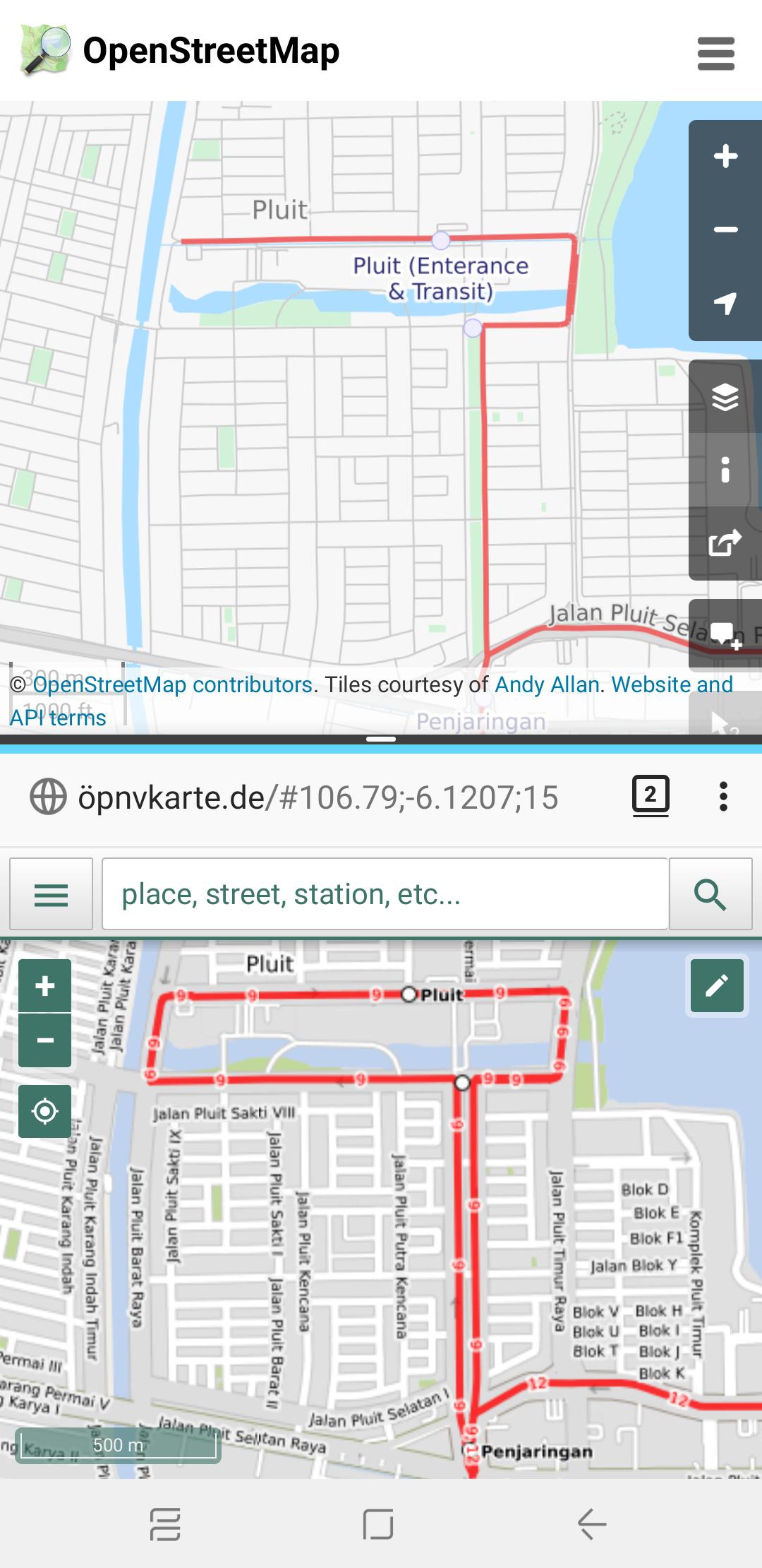
Before and After map of Transjakarta Corridor 9 route, between Pluit and Penjaringan bus stops

Legacy Tags that I’d like to keep for compatibility:

  • amenity=bus_stop for PTV1 compatibility on bus stations
  • corridorXX=yes: assigns which Transjakarta corridors are served, such as corridor9=yes for Corridor 9 and corridor12=yes for Corridor 12 (see Implementation Notes if you are a developer utilising this tag for queries)
  • HOTOSM InAWARE tags
  • network=Transjakarta, now also reinforced withnetwork:wikidata and wikidata values
  • shelter=yes
  • shelter_tj=yes (see Implementation Notes if you are a developer utilising this tag for queries)

Things I REMOVED

  • service=TransJakarta, since this is unacceptable by Osmose and other QA tools (see Implementation Notes if you are a developer utilizing this tag for queries)

New things that I added

  • bus=yes to meet PTV2 requirements for bus
  • Route relation-specific additions:
    • New route relations will be added for Corridor sub-routes (e.g. Corridor 1A, 9M, etc.), night services (e.g. M1 for Corridor 1; though I’ll consult with other OSM Public Transport implementations in other places)
    • Duplicating roads since many Transjakarta networks operate on one-way roads
    • network:wikidata=Q1671143 for Transjakarta, then add Wikidata values for each route relation, e.g. wikidata=Q12492249 for Corridor 5
    • public_transport:version=2 to enable JOSM and Osmose debugging
  • Shelter/station-specific additions:
    • Stations may now be represented as a Relation for those which have split platforms and/or multiple objects in OSM, such as in some Corridor 9 stations which are split by toll roads/expressways
    • Transit-Oriented Development (TOD) areas are now represented as a separate Relation to connect multiple stations serving different networks
    • covered=yes, since Transjakarta stations are fully covered (in conjunction to shelter=yes)
    • departures_board=realtime since all Transjakarta stations (except Metrotrans, Miktrotrans, and Royaltrans services) have a live bus timetable, which can also be accessible through API at http://api.jakarta.go.id
    • public_transport=stop_position and public_transport=platform, see PTV2 on OSM wiki for specific implementation
    • smoking=no due to government laws, though not necessarily applied to all stops and stations across Jakarta
    • wheelchair=yes/dedicated/partial/no (optional)

Implementation Notes (for apps and services)

  • Please use the Route Relation instead of corridorXX=yes for network queries. After checking on taginfo.openstreetmap.org most of corridorXX tags are only used in Indonesia.
  • Additionally, you may include hard-coded Relation IDs which belong to Transjakarta network.
  • Please use highway=* and Transjakarta Route Relation IDs instead of service=TransJakarta to query roads which belongs to Transjakarta, as some parts of the routes do NOT have a separate road (or Kassel Kerbs)
  • Please use Transjakarta Route Relation objects with role=platform or role=stop_position instead of shelter_tj, as some Transjakarta (especially Royaltrans and Metrotrans) networks do stop at regular bus stations.
Location: RW 04, Pluit, Penjaringan, North Jakarta, Special Region of Jakarta, Java, 14440, Indonesia

Mapping Indonesian Payment Systems and Proposal for New Payment Tags

Posted by Reinhart Previano on 20 April 2019 in English. Last updated on 8 August 2022.

This post is neither created nor endorsed by companies involved in establishment of payment systems listed below.

The OpenStreetMap payment: tag allows mappers to tag stores that accept certain payment methods (cash, debit and credit cards, etc.). Currently, the wiki only accepts those payment methods, so now I decided to introduce new ones in Indonesia.

What’s new?

First, let me introduce five new tags: three of them are dedicated to Indonesia’s newly-established GPN (Gerbang Pembayaran Nasional, literally National Payment Gateway). Currently it is a debit card switching network, similar to that of VISA and MasterCard (Maestro). Here, I propose payment:gpn_debit to be used in all merchants accepting GPN debit cards.

The Indonesian government has plans to replace existing payment networks in Indonesia with GPN, so does with credit cards and mobile wallets (e.g. Apple Pay and Google Pay). I am proposing payment:gpn_credit and payment:gpn_qris to be reserved for later use. The latter refers to the QR Indonesian Standard (QRIS) payment, similar to the SGQR system in Singapore.

The rest of these tags are payment:akulaku and payment:grabpay, reserved for Akulaku Pay and GrabPay. Both payment systems are currently used in multiple countries across Southeast Asia. In Indonesia, GrabPay has merged to Indonesian digital wallet app OVO, so merchants using OVO-GrabPay QR code sticker (see below) should be tagged with payment:grabpay=yes and payment:id_ovo=yes.

OVO-GrabPay merchant sticker

There are a bunch of other proposed tags prefixed in id_* (e.g. payment:id_ovo and payment:id_gopay). This prefix is used for payment services operating only in Indonesia, to avoid trademark conflicts with other countries, such as Indonesia’s GO-PAY with GOPAY (Malaysia), GoPay (Czech Republic) and GoPay.me.

A full list of posposed (and existing) payment: tags are available on https://telegra.ph/Konvensi-tag-payment-di-Indonesia-04-19 , written in Bahasa Indonesia to serve as guidelines for Indonesian mappers. Note that some tags might be replaced with payment:gpn_qris once after QRIS becomes functional.

How will users use this data?

On the OpenStreetMap.org website, users can look for accepted payment methods from the node/line/area details. Unfortunately, payment tag details are not available in some OSM clients and the Nomimatim website. Oh, some users might hunt for stores with discounts and cashbacks offered by digital wallet apps (currently this is a real craze in Indonesia).

Screenshot

Note: Some of the payment metadata is incorrect, and the shop was edited before the tag proposal. Major Alfamart stores now accepts cash, debit and credit cards, contactless prepaid cards Flazz (payment:id_flazz), Mandiri e-money (payment:id_mandiri_emoney) and BRIZZI (payment:id_brizzi), as well as digital wallet service GO-PAY (payment:id_gopay).

Besides that, tagging these shops may also be useful for research. For example, a TagInfo search of stores accepting Alipay reveals that the service is accepted outside China to serve international visitors (especially China). As one of the largest countries in the world, having a complete map of Indonesian payment systems could be beneficial for researchers to evaluate the effectiveness of payment services as one of the economy infrastructures in Indonesia.

And for the OSM community, adding new payment: tags from Sabang to Merauke will get them busy again.

Location: RW 02, Gambir, Central Jakarta, Special Region of Jakarta, Java, 10110, Indonesia

Fixing Genting Highlands

Posted by Reinhart Previano on 1 December 2018 in English.

Changesets: https://www.openstreetmap.org/changeset/65071147 https://www.openstreetmap.org/changeset/65071317

Removed 20th Century Fox World (constructed roads)

I reverted the mapping of roads under construction in this area as 20th Century Fox decided to stop the project (and Genting sues them). No, I’m not planning to change the type of Fox World’s area to brownfield, as this case have not been settled yet. However, I might want to improve the mapping of other theme parks in OSM, as other mappers have mapped some with great details. (such as in Universal Studios Japan)

Readjusting First World Hotel towers

Prior to these changesets, the First World Hotel consists of 2 towers: Tower 1 and Tower 3. The building which is named as Tower 3 in OSM is supposed to be Tower 2, as Tower 3 is built as an extension to Tower 2. I have stayed there once, so I also added a cafe in the Tower 3 lobby.

Next, I also adjusted the First World Hotel towers based on the newer DigitalGlobe imagery. Towers 1 and 2 are supposed to be curved, so I added that change to OSM. (You can confirm the shape using the older Bing imagery) As a result, these towers are aligned better towards Genting International Convention Center as well as the SkyAvenue shopping mall.

Skytropolis

During the development of 20th Century Fox World, Genting also have prepared a renovation of the First World Indoor Theme Park which will become “Skytropolis”. As the construction of this new the park is almost complete, I decided to add this to OpenStreetMap.

Other things

  • Added more parking lanes near to Genting Grand hotel

A note on previous changesets

This post is a continuation of my previous diary which I considered it controversial. Here are my next plans to fix those issues:

  • First, I am going to resolve where the new First World Lobby paths should actually exit. Even though I have justified this against the old satellite imagery, I will be there to verify the Avenue of Stars exits by next month.
  • Next month is also my next Genting trip (hence I’m motivated to improve Kuala Lumpur International Airport and Genting Highlands prior to travelling), so expect some additions of restaurants and stores starting from Theme Park Hotel to First World, as well as Awana SkyCentral and Genting Premium Outlets at Awana /Gohtong Jaya.

Mapping the New Genting Highlands

Posted by Reinhart Previano on 7 November 2018 in English. Last updated on 8 November 2018.

Major Edits in Resorts World Genting, Malaysia

Today I am going to announce a large change to the OpenStreetMap database. What is it? The complete removal of the old Genting Highlands Theme Park assets.

If you are using Bing, MapBox, or DigitalGlobe (Premium) satellite imagery, you are still seeing the old face of Genting theme park.

Image 1

However, if you use the standard DigitalGlobe imagery, you will see that everything has changed since 2015, the last time I visited this place.

Image 2

I have to admit that adding and editing existing buildings and roads here are difficult. I ran into issues such as the traffic flow for vehicles exiting from the First World Hotel lobby. In making these changes, I relied on some sources:

  • “Genting Highlands June 2018 and September 2018 Progress Update” videos by SouthernCorridorMalaysia on YouTube
  • The indoor directory of Genting SkyAvenue, which can found from the official website here
  • The concept art of 20th Century Fox World Malaysia

Comparison

Before the start of this project I compared the existing map of Genting Highlands on Google Maps and HERE WeGo.

Here are some notes after adding the changesets.

  • HERE WeGo is still showing the former First World underground links, which also proven the existence of underground tunnels connected to roads near to the Avenue of Stars.
  • These changesets are primarily based on DigitalGlobe Standard imagery, where Google Maps’ interpretation of Genting is based from. Hence, the new buildings (especially the SkyAvenue) might look similar to GMaps, even though they are directly traced against the imagery source.
  • The new First World Plaza exit routes have been changed. Now it follows the former Outdoor Theme Park road located at the lakeside as shown in an older satellite imagery (see comments), to the Arena of Stars underground tunnel shown in HERE.
  • There is a distortion in the satellite imagery around SkyCasino, which GMaps weren’t aware of and mapped the distorted building. The two YouTube videos, as well as the official SkyAvenue directory above prove the correct shape of the building.

What Has Changed in Genting?

Here are some highlights on major changes in Genting Highlands:

  1. Closure of the old Genting Outdoor Theme Park [1]
  2. Closure of the old First World Indoor Theme Park [2]
  3. Renovation of the old Theme Park Hotel, which later changed its name to “Hotel On The Park” then reverted to its former name [2]
  4. Construction and opening of Awana SkyCentral [2]
  5. Construction and opening of SkyAvenue [1]
  6. Construction and opening of Awana SkyWay, connecting Awana SkyCentral to SkyAvenue via Chin Swee Temple [2][3]
  7. Construction and opening of Grand Ion Delemen Hotel [2]
  8. Construction of the 20th Fox World Malaysia (Delayed) [1]
  9. Construction and opening of Skytropolis, the new First World Indoor Theme Park [3]

[1] Shown on changesets mentioned in this article [2] Already added/changed/deleted prior to this article [3] Might have some mapping issues and/or planned to be edited soon

What Has Been Changed in OpenStreetMap?

A lot: see

Added “Genting SkyAvenue” and “Genting SkyCasino”

Note: The prefix word “Genting” is not neccessary, while this could ease people for searching this new shopping mall in Genting.

Genting SkyAvenue, or simply “SkyAvenue”, is a new shopping mall located at part of the former Outdoor Theme Park area. This mall, stretching from the First World Plaza to the Avenue of Stars, hosted many tenants that were previously available at the First World Plaza (FWP). Most of the FWP areas, such as the “Genting Walk”, has been closed for the opening of the new “Skytropolis” theme park.

Removed two “lakes” in the former Outdoor Theme Park area.

Image 3, from Wikimedia Commons These “lakes” were built for water attractions on the theme park. Now they have been closed for the construction of the 20th Century Fox World Malaysia.

However, the Outdoor Theme Park roads that surrounds the larger lake has been added as the current exit path of First World Plaza (see comments)

Modified First World Hotel lobby exit paths

Initially, I thought that vehicles exiting from the First World Hotel are guided through the new tunnels at SkyAvenue to the gate where the First World Bus Terminal was built. After consulting with the SkyAvenue indoor directory, I agreed to modify the path to exit at the Arena of Stars.

There are future tenants opening at the Ground Level of SkyAvenue, which does not indicate any vehicle routes. However, the new elevated track is built near the former Bus Terminal, which directs the vehicles to the multi-storey parking area at SkyAvenue.

New Paths at 20th Century Fox World Malaysia

Here, I would also like to give a head start of the mapping progress of the future outdoor theme park.

At the first steps I added some paths that are most likely to be part of the main roads in this theme park, supported by the early concept images. I assigned these paths with highway:road before the theme park is finalized to the public.

At the end, here are a list of changesets for you to discover: #64266771, #64269329, #64269852, #64269863, #64270973, #64279712 and #64280005

Location: Gohtong Jaya, Genting Highlands, Bentong, Pahang, 69000, Malaysia

Merging Rivers

Posted by Reinhart Previano on 1 November 2018 in English.

Continued from the previous post, I decided to improve and merge the parts of the Citarum river that were added as a part of a HOT (Humanitarian OpenStreetMap Team) project. Some river paths are smoothed to look great in large zooms.

Before image

After image

Before image

After image

Justification of the Correct River Flow

On the previous post I was confronted by an issue where the river direction in the HOT changeset was the reverse of my river direction. Some users recommend some river QA tools, while the correct river direction can be determined geographically, even from satellite imagery.

Rivers flow from a high land level to a lower one. Hence, it is also very common to recognize that rivers flow from mountains to beaches.

image 
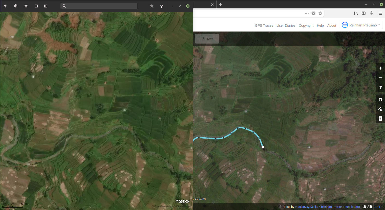
River position against a series of mountains

From the image above you can see that the river is connected to a reservoir on the left side. The water then flows from the reservoir all the way to Karawang, which ends at the beaches of Pantaibahagia beach with no delta present. This means that the Citarum river requires a source which is connected to the reservoir.

Next, let’s talk about the small dam located which is located here. It is located near to the intersection of the rivers shown in the overview map on the previous post.

image

From this satellite imagery the left side of the river seems to carry fewer water volume compared to the right side, based on the difference of dirt area visible in both sides. This is just another proof that the river in the changeset is flowing from right to left.

Lastly, using the same imagery on the last node of the mapped river section (see changeset), we can prove the correct direction of the river. Here, we can follow the unmapped part of the river to find several tributaries facing to the left.

image

image

Location: Cisomang Barat, West Bandung Regency, West Java, Java, 41164, Indonesia

Connecting Rivers

Posted by Reinhart Previano on 30 October 2018 in English.

False-color render of river A false-color render of Citarum river. Note that the unmapped line shown above is not geographically accurate.

Days after my attempts in extending the Citarum River, Indonesia (see this post), a HOT (Humanitarian OpenStreetMap Team) project added an unconnected part of the same river (highlighted in above image in dark blue color). Today, I have mapped the gap between both rivers to be joined into one in Changeset #64012348.

One thing that surprises me in the HOT changeset is that the river that flows in an opposite direction with my drawn rivers. I am confident enough to change the direction of the river to follow the direction of the dam in (-6.69206,107.41797) as well as the tributaries found at the unmapped part of the river (after the HOT changeset).

I am planning to do some QA on the HOT-added river before merging with the main river line.

Location: Cisomang Barat, West Bandung Regency, West Java, Java, 41164, Indonesia

Finished Result

Continuing from my previous post, I have submitted 8 new changesets (#63876977 #63877356 #63885737 #63885836 #63947501 #63947694 #63965928 #63976086) to add the aircraft parking lanes in klia2 (Kuala Lumpur International Airport, Terminal 2).

Additional Notes

  • Someone has suggested in the previous post to refine the aeroways (e.g. taxiways) in the airport and adding metadata to them (such as taxiway width), which I would be happy to do so. However (as OSM does not allow paths encoded by Bézier curves), I need to both improve and simplify the appearance of the curves to save space on the map database.
  • Someone added some footpaths inside the airport terminal which connects to AirAsia’s RedQ (headquarters building), but these paths are currently disconnected from the Gateway@klia2 (the nearby shopping plaza) and the gates.

Footpaths

  • I am also considering to add airport gate “bridges” to KLIA, which has been mapped in Singapore’s Changi Airport. Meanwhile, I am planning to extend the Citarum River (West Java, Indonesia) and add details to Jakarta’s Soekarno-Hatta International Airport and KLIA Terminal 1 before continuing on improving klia2.

Changi OSM view of Singapore’s Changi International Airport, where all airport gates (not just gate numbers) are added on all of its terminals.

Location: 2.741, 101.688
  1. Added Pier P gate numbers
  2. Added Pier Q gate numbers
  3. Added Pier K/L gate numbers

I have discussed those changesets in Part 1 and Part 2. Now it’s time to complete this map.

I recently added the final gates in klia2, which is located at Pier J (Domestic). That’s the main message, however someone have added some lengths of lines connected to the taxiway. Unfortunately, these are not visible in the regular OpenStreetMap layer.

Before changeset Before changeset

Apparently, they are the aeroway:parking_position paths. These paths are self-explanatory, which are the ones followed by an aircraft to safely deliver passengers to the parking spot (and terminal gates). Bing satellite imagery provides a clear view of these lines to be added.

That’s the motivation to complete the Pier K/L parking position lines in Changesets 63867934 and 63868266. Actually, there are some paths that are still unmapped, specifically in the gates K20, L20 and L22. aeroway:parking_position lines will be added in other piers (and hopefully Terminal 1) soon, to make the entire KLIA to be better mapped for the public.

Location: Kuala Lumpur International Airport, 64000, Malaysia

Continuing from one of my previous post I have added more gates for Pier K/L and Pier Q.

After changeset After changeset

Before this changeset is submitted, the map of klia2 only has a full set of Pier P gate numbers (added by myself) and a lonely Gate Q10. I reused the old Q10 node in these changesets so there are fewer changes to the map database.

Additionally, as in Changeset 63791506, I decided to join the Airport Gate “nodes” to the entire klia2 building. This makes node placement easier as I am no longer need to estimate the equal distance between the airport’s edge to those nodes.

The Pier K/L is, perhaps, another unique feature of the klia2 Terminal. The official website from Malaysia Airports states that even though Pier K is intended for domestic flights and Pier I for international, they actually take place on the same pier area on different level heights. (Pier K gates are on Level 1A, while Pier L gates are on Level 2) Pier L has one additional gate, L22, which located very near to gates K20 and L20. To remove confusion I decided to re-join these numbers together in Changeset #63793136

After changeset After changeset

As you can see above those gate numbers actually refer to three aircraft parking spaces nearby, where L22 has the largest one (for long-haul international flights such as AirAsia X). However, by joining the gate numbers in one point, passengers can simply know the direction they need to go to the gate. In KLIA Terminal 1 gate numbers are applied to apron areas instead of terminal buildings, but it would be good to add nodes such as lifts for informing passengers for waiting room areas for those remote gates.

Pier J gate numbers are coming soon. Besides that, a skybridge above the aircraft taxiway is a great design.

Location: Kuala Lumpur International Airport, 64000, Malaysia

That's a lot of changesets! That’s a lot of changesets!

Back then, when my relatives come back from Bandung, Indonesia to Jakarta, I was told by them that they were in a rest area on the 97 kilometer mark of the Purbaleunyi toll road. I tried to search on OpenStreetMap and there were no results.

Apparently, that rest area were not added to OSM yet. So, I started to add that place on Changeset #61579993.

Oh, no! Satellite images show that there are roads and bridges nearby, yet there were no nearby roads listed to the OSM database. So, I added a few roads, in Changesets #61580342, #61761820, #61761878, and #61761940; then #62783689 and #62783948 (after adding some rivers).

Wait, did I say “a few”? Apparently long lines of unknown roads were added to the OSM database, and I have successfully connected them to existing roads. I changed the road type “Service Roads” to “Residential Roads” on some roads near to small houses of multiple villages. That makes places to feel more connected in OSM, and makes OSM editing to be more addictive.

Then, I added some rivers (and more roads) in Changesets #61762051, #61879226, #61879557, #63742480. Apparently this one is a tributary of the Citarum River (pardon the name of the last changeset which refers to “Ciliwung”), and it will be a long way to trace this to its origin, which I expect to be located on the mountain range nearby.

Latest changeset area and the nearby mountains Latest changeset area and the nearby mountains

I have recently submitted a changeset to add gate numbers in klia2. Although this seems easy, this terminal have a unique odd-even gate number assignments, which is unlike the Terminal 1.

Displayed map of klia2, before changeset Displayed map of klia2, before changeset

Displayed map of klia2, after changeset Displayed map of klia2, after changeset

Current displayed map of KLIA (Terminal 1), with gate numbers assigned Current displayed map of KLIA (Terminal 1), with gate numbers assigned

There is still work to be done in adding gate numbers to the other piers of the terminal, but I would be glad for others (especially the Malaysian OpenStreetMap community) to help in adding these as well. I am also planning to improve the Genting Highlands map in early 2019.

Location: Kuala Lumpur International Airport, 64000, Malaysia

Changeset details: https://www.openstreetmap.org/changeset/56642302

The Central Park Mall is one of the popular shopping malls in West Jakarta, Indonesia. It is also inspired by the design of the Central Park in New York City.

This mall has a park for visitors to walk around, called the Tribeca Park. Aside from that, this mall is also connected to the Tribeca (a 2-storey section of Central Park Mall consisting of several restaurants) and Neo Soho (the shopping mall below the new Soho apartment near to Central Park). These malls are owned by the same developer, PT. Agung Podomoro Land.

In this changeset I added the new Tribeca (mall) section at the other side of Tribeca Park, including the skybridge connecting Tribeca ↔️ Central Park ↔️ Neo Soho. I also added more details on Tribeca Park itself, including added new footpaths, restaurants, ponds, fountains and a new escalator. There’s 1 more pond left unmapped, as I need to re-check on site for the accuracy of its position.

So far, here’s the changes I made to this shopping mall. As of now, there might be some mistakes in my changes to, which I will fix it later.

Before

After

And here’s how my work is compared with Google Maps (as of 25 February 2018):

Google Maps version of the mall

Location: RW 06, Tanjung Duren Selatan, Grogol Petamburan, West Jakarta, Special Region of Jakarta, Java, Indonesia